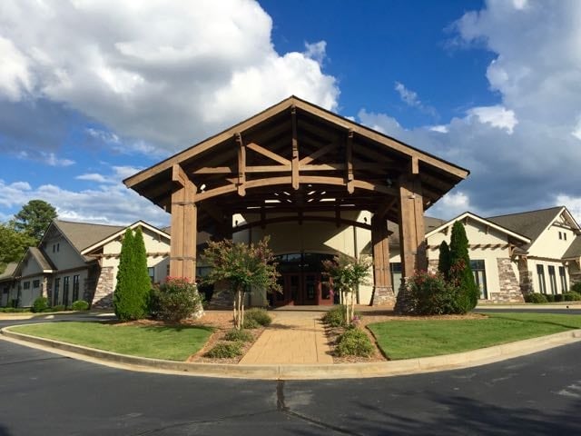
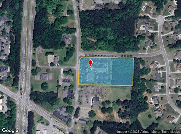
Property Record
190 Handley Rd, Tyrone, GA 30290

NEARBY LISTINGS FOR SALE OR LEASE
Property Detail
190 Handley Rd
Atlanta-Sandy Springs-Roswell, GA
Grove Park
07-27-00-067
4.16AC HANDLEY ROAD
Medicalbuilding
Fayette
X
Georgia
13077C0180D
117
2024
4.16 AC
2024
Fayette/Coweta County
140203
Atlanta
17,330 SF
DEMOGRAPHICS near 190 Handley Rd
1 Mile
3 Mile
5 Mile
2024 Total Population
2,127
14,214
54,209
2029 Population
2,260
15,163
57,862
Pop Growth 2024-2029
+ 6.25%
+ 6.68%
+ 6.74%
Average Age
42
42
41
2024 Total Households
729
4,988
19,636
HH Growth 2024-2029
+ 6.31%
+ 6.70%
+ 6.63%
Median Household Inc
$95,147
$93,534
$92,857
Avg Household Size
2.90
2.80
2.70
2024 Avg HH Vehicles
3.00
2.00
2.00
Median Home Value
$339,285
$374,721
$364,931
Median Year Built
1994
1996
1997
Nearby Places
Map Layers
Map Styles
 Street
 Aerial
- Restaurants
- Banks
- Shops
- Fitness
- Groceries
PUBLIC TRANSPORTATION
AIRPORT
Hartsfield - Jackson Atlanta International
DRIVE
WALK
Distance
Hartsfield - Jackson Atlanta International
29 min
19.3 mi
Freight Ports
Georgia Ports - Savannah
DRIVE
WALK
Distance
Georgia Ports - Savannah
289 min
245.8 mi
SALE & LEASE HISTORY
LISTING DATE
SALE/LEASE

Sep 25, 2016
For Lease
Jan 06, 2019
For Lease
Feb 19, 2025
For Lease
Nearby Properties
Address
Land Use
TOTAL SIZE
Lot Size
Zoning
Address
Land Use
TOTAL SIZE
Lot Size
Zoning
412,253 SF
134.50 AC
Address
Land Use
TOTAL SIZE
Lot Size
Zoning
194,839 SF
25.40 AC
C GC
Address
Land Use
TOTAL SIZE
Lot Size
Zoning
96,409 SF
12.74 AC
C GC
Address
Land Use
TOTAL SIZE
Lot Size
Zoning
93,925 SF
5.18 AC
C GC
Address
Land Use
TOTAL SIZE
Lot Size
Zoning
80,800 SF
9.39 AC
C C2
Address
Land Use
TOTAL SIZE
Lot Size
Zoning
80,956 SF
60.90 AC
Address
Land Use
TOTAL SIZE
Lot Size
Zoning
125,421 SF
12.99 AC
C GC
Address
Land Use
TOTAL SIZE
Lot Size
Zoning
72,376 SF
30.30 AC
Address
Land Use
TOTAL SIZE
Lot Size
Zoning
14,636 SF
6.50 AC
C OI
Address
Land Use
TOTAL SIZE
Lot Size
Zoning
36,900 SF
8.12 AC
C OI
Address
Land Use
TOTAL SIZE
Lot Size
Zoning
49,935 SF
3.99 AC
C GC
Address
Land Use
TOTAL SIZE
Lot Size
Zoning
66,390 SF
3.61 AC
I M1
Address
Land Use
TOTAL SIZE
Lot Size
Zoning
60.89 AC
I M1
Address
Land Use
TOTAL SIZE
Lot Size
Zoning
30,397 SF
24.50 AC
Address
Land Use
TOTAL SIZE
Lot Size
Zoning
12,859 SF
50.50 AC
Address
Land Use
TOTAL SIZE
Lot Size
Zoning
15,440 SF
10.86 AC
C C1
Address
Land Use
TOTAL SIZE
Lot Size
Zoning
17,248 SF
3.47 AC
C OI
Address
Land Use
TOTAL SIZE
Lot Size
Zoning
49,680 SF
2.92 AC
I M2
Address
Land Use
TOTAL SIZE
Lot Size
Zoning
26,022 SF
3.48 AC
C C2
Address
Land Use
TOTAL SIZE
Lot Size
Zoning
24,100 SF
4.30 AC
C C3
Address
Land Use
TOTAL SIZE
Lot Size
Zoning
27,270 SF
3.28 AC
C C2
Address
Land Use
TOTAL SIZE
Lot Size
Zoning
60,099 SF
3.60 AC
Address
Land Use
TOTAL SIZE
Lot Size
Zoning
14,375 SF
1.85 AC
C C1
Address
Land Use
TOTAL SIZE
Lot Size
Zoning
3,794 SF
1.74 AC
C C2
Address
Land Use
TOTAL SIZE
Lot Size
Zoning
14,966 SF
2.43 AC
C GC
Address
Land Use
TOTAL SIZE
Lot Size
Zoning
15,512 SF
11.26 AC
Address
Land Use
TOTAL SIZE
Lot Size
Zoning
14,426 SF
2.35 AC
C C1
Address
Land Use
TOTAL SIZE
Lot Size
Zoning
62,322 SF
25.50 AC
I M1
Address
Land Use
TOTAL SIZE
Lot Size
Zoning
21,063 SF
2.63 AC
C C1
The World's #1 Commercial Real Estate Marketplace
Connect with us
© 2026 CoStar Group
The information above has been obtained from sources believed reliable. While we do not doubt its accuracy we have not verified it and make no guarantee, warranty or representation about it. It is your responsibility to independently confirm its accuracy and completeness. Any projections, opinions, assumptions, or estimates used are for example only and do not represent the current or future performance of the property. The value of this transaction to you depends on tax and other factors which should be evaluated by your tax, financial, and legal advisors. You and your advisors should conduct a careful, independent investigation of the property to determine to your satisfaction the suitability of the property for your needs.